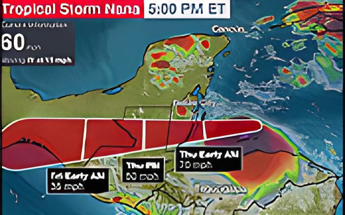
Turning now to NEMO, we spoke to the national coordinator this evening about what you should expect from Tropical Storm Nana.
Speaking to us via phone from NEMO headquarters in Belmopan, he says that the storm track shows that the Stann Creek, Belize, and Cayo Districts should pay very keen attention:
Col. Shelton Defour (Ret'd.) - Coordinator NEMO
"Definitely you will get some heavy winds in Belize District and even in the Cayo District, because that projected path shows it going through Belize into Guatemala. So it's almost like we are looking like a next Greta, Richard and Earl. This would be like historically the 4th storm in history to literally go right through the center of the country. So if you are north of where the eye of the storm will pass, you will definitely feel some wind impact."
Jules Vasquez
"Where do you all believe on the current track it will make landfall?"
Col. Shelton Defour (Ret'd.) - Coordinator NEMO
"We are looking between the Belize District and the Stann Creek District, in that range, which then puts you as it moves due west into the Cayo District. So the brunt of the impact when it is strongest along the coast still over water is between Stann Creek and Belize District."
Jules Vasquez
"Is it any consolation for you all that between last night and this morning when the hurricane hunter flew in it did not find that the storm had significantly strengthen. It still remains a tropical storm."
Col. Shelton Defour (Ret'd.) - Coordinator NEMO
"In a way it is because psychologically for people it means that okay it's only a tropical storm, even though it will have some damage and could have some devastating effects. However, for us we were more monitoring the wind speed and the strength of the winds for the tropical cyclone because a hurricane 74 miles per hour and a tropical storm at 72 miles per hour - you are only talking a 2 miles difference which in many regards isn't much. So this is one of the things that we teach our staff that don't worry too much about the category, worry about the strength of the winds associated with that tropical cyclone and the characteristics of the cyclone - how much rainfall, what is the likely storm surge height, what is the speed of movement to know how long it would stay over land and to calculate what could be the possible impacts. Let us see what is coming, because you had storm like Iris, small and compact, 30 miles in radius and you got storm like Keith, almost 200 miles in radius, You had storm like Dean, didn't even dump about 4 inches of rainfall. Keith dumped 40-44 inches of rainfall. We expected 20 feet storm surge from Dean, we didn't get that in 2006. Every tropical cyclone have its own characteristics. What are the main risks associated with this cyclone that is now approaching the country."